Failure to detect a charted shoal en route to an anchorage led to the grounding of a bulk carrier near Prince Rupert, British Columbia, last year, Canada’s Transportation Safety Board (TSB) has determined.
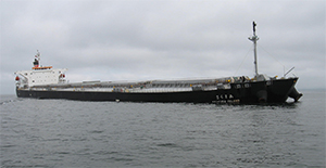
Amakusa Island ran aground on July 14, 2014, after picking up a load of coal at Ridley Island. The incident followed an unexpected schedule change that sent the ship to an unfamiliar anchorage, the TSB said in an investigative report.
After completing the master-pilot exchange, the bridge team had planned to depart Ridley Island for the Triple Island pilot station offshore where the pilot would disembark. Shortly before departure however, the ship’s charterer requested that the vessel proceed to an anchorage so that some issues regarding the cargo could be resolved.
The Prince Rupert Port Authority instructed the crew to proceed to Anchorage 25. The master and pilot identified the anchorage on the chart and prepared for departure at 2205.
“Neither the master nor the pilot had previously been to that anchorage, which is southwest of the vessel’s departure position,” the TSB wrote in a news release. “The route to the anchorage passed in proximity to a charted shoal that was too shallow for the vessel. This shoal was not detected by the bridge team while planning the revised route or while monitoring the vessel’s progress.
“Additionally, the pilot’s portable pilotage unit was not configured with all of the available route planning and monitoring features to assist in detecting navigational hazards.”
The chart in use on board Amakusa Island was United Kingdom Hydrographic Office (UKHO) Chart 4936, which is an exact replica of Canadian Hydrographic Service (CHS) Chart 3957. The pilot was using a raster chart on his PPU that depicted the same data as CHS Chart 3957.
The course line passed between two navigational hazards that the bridge team had marked on the chart: Gull Rocks and a 39-foot shoal, both of which were roughly 0.4 nm from the course line. The pilot verified the course line the master had plotted to ensure that the correct anchorage had been identified and that there was sufficient water depth along the course line. The shallowest charted depth along the course line was determined to be 72 feet.
CHS Chart 3957, using bathymetric lines, depicts the shoal on which Amakusa Island grounded. The number of bathymetric lines around the 35-foot shoal indicates that the seabed rises at this location.
The vessel struck bottom at 2209. Approximately a half-hour later, after the master and pilot had examined the chart in detail, it was confirmed that the vessel was aground on a shoal with a charted depth of 35 feet. The vessel was approximately 460 feet south of the plotted course line.
The vessel was refloated on the rising tide about four hours after the grounding. After the vessel’s tanks were sounded, it was determined that the forepeak tank and the starboard ballast tanks No. 1 and No. 2 had sustained damage and were taking on water.
Later that day, divers assessed the damage to the vessel and began carrying out repairs. By September, temporary repairs had been completed under the guidance of the vessel’s classification society, and the ship departed the next day for Japan.
Following the occurrence, the CHS updated Chart 3957 by marking an “R” adjacent to the 35-foot shoal to indicate the type of bottom composition as rock or rocky. The UKHO issued a similar update to Chart 4936.
One month before the Amakusa Island grounding, the British Columbia Coast Pilots Ltd. and the Pacific Pilotage Authority reached an agreement on new requirements for pilots. All pilots, regardless of years of service, must undergo mandatory assessments every five years. The agreement called for improvements upon the currency program to better monitor individual pilot’s assignment history and identify any lapses in currency. It creates additional opportunities for pilots to obtain recent experience for the areas in question.
“If effective strategies to help all pilots maintain thorough and current knowledge of the areas to which their license applies are not in place, there is a risk that pilots will not be sufficiently familiar with these areas to carry out their duties safely,” the TSB said in its Amakusa Island investigation report.
In November 2014, Iino Marine Services Co. Ltd., the management company responsible for Amakusa Island, installed an electronic chart display and information system (ECDIS) on board. The company initiated training for the crew in various aspects of human performance, the TSB report said. Iino Marine could not be reached for comment.