
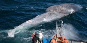
While humans once stood in awe of the size and strength of whales, the roles have been nearly reversed since the mid-20th century as increasing ship traffic has added insult to the injury done by the era of whaling.
To reverse the trend, marine scientists, environmental advocates and sympathizers in the nautical community are trying to harness technology to protect whales by focusing on reducing the risk of vessel collision.
On the West Coast, a new online tool — the fruit of collaboration between the Benioff Ocean Initiative (BOI) at the University of California (UC) Santa Barbara and leading whale researchers nationally — aims to detect the presence of whales in a given area in near real-time. The first beneficiaries of Whale Safe, as the initiative is known, are intended to be the cetaceans inhabiting the Santa Barbara Channel off the coast of California.
Morgan Visalli, a BOI scientist and project lead, said 2018 and 2019 were the worst years on record for fatal ship collisions involving whales in the state’s waters, and the hope is that data from Whale Safe can bring an improvement.
The initiative involved three years of work between BOI, UC Santa Cruz, the Scripps Institution of Oceanography in San Diego, Texas A&M University at Galveston, the University of Washington, the National Oceanic and Atmospheric Administration’s (NOAA) Southwest Fisheries Science Center, and the Woods Hole Oceanographic Institution (WHOI) in Massachusetts.
The project was spurred by whale fatalities in the Santa Barbara Channel, a passage as narrow as 16 nautical miles that carries a large portion of ship traffic to and from the ports of Los Angeles and Long Beach. Since the 1980s, collisions averaging one every two months have marred the relationship between humans and cetaceans in the area. To complicate matters, about a decade ago endangered blue, humpback and fin whales started feeding regularly north of Santa Cruz and Santa Rosa islands, which form part of the channel.
To help protect the cetaceans, Whale Safe combines data from three sources: a subsurface acoustic system that detects whale calls; whale sightings by scientists reported by mobile app, and forecasted activity on whale feeding grounds. The tool can display near real-time information about the presence of whales, albeit not with the level of precision needed to prescribe anything more than caution and lower speeds. But those actions alone can be enough to meaningfully reduce the likelihood of collisions.
How the shipping industry views the initiative is an open question. Capt. Kip Louttit, executive director of the Marine Exchange of Southern California, said he was part of the working group preparing the way for Whale Safe about two years ago. “It seems like a good thing, but I haven’t heard from the organization for a number of months,” he said in November.
Louttit stressed that Whale Safe is a private initiative, so it doesn’t have the force of law behind it. Moreover, the data it provides is limited. “It is not precise. It is hydrophones in the water that will detect the whales, but I am not sure if it provides bearings or just information that whales have been heard,” he said.
Another whale protection initiative by NOAA and several partner organizations in 2007 established a voluntary 10-knot speed limit for large ships transiting the area. That measure has garnered considerable support from the shipping industry, Visalli said, but she added that many vessels still exceed that speed limit — a fact that researchers believe leads to a sharply increased risk of collisions.
The Santa Barbara Channel is not the only region where speed regulations have been attempted. In the Cabot Strait between Newfoundland and Nova Scotia, a voluntary slowdown measure put in place by Transport Canada to protect North Atlantic right whales has been largely ignored, according to the conservation group Oceana.
Oceana reported that between 2017 and 2020, more than 30 right whales died from either ship strikes or incidents involving fishing gear, the bulk in Canadian waters. The International Union for Conservation of Nature has listed the species as critically endangered, with only 400 remaining on the planet.
Oceana said its tracking of ship speeds in the Cabot Strait between the end of April 2020 and the middle of June was not encouraging. Vessels longer than 13 meters (42 feet) had been asked to slow down to 10 knots, but 67 percent (464 out of 697) were traveling faster than the limit, and some were going 20 knots or more.
Because of such poor compliance, Oceana has asked Transport Canada to make the speed limit in the Cabot Strait mandatory rather than voluntary. In the meantime, the broader public has been invited to lend its eyes and voices to the effort. The key will be improved monitoring and surveillance, Oceana said, and that’s where another new tool comes into play: Ship Speed Watch.
Ship Speed Watch, which can be accessed at www.usa.oceana.org, updates daily with automatic identification system (AIS) signals from vessels that are operating in speed restriction zones. It can provide data going back 30 days, so vessel operators who are not complying can be subject to a lengthy window of regulatory scrutiny.
According to the Oceana, it is easy to use Ship Speed Watch — just click on a point on the map to find the name of a vessel, its operating speed and its Maritime Mobile Service Identity (MMSI) number. Alternatively, a user can type in the name of a ship in the drop-down box to find a vessel of interest. Further narrowing the search by data range can yield more information about the vessel’s presence in a speed restriction zone or critical habitat area along the east coast of Canada and northeastern U.S. •