(LONG BEACH, Calif.) — Imagine driving your car down a narrow road that you cannot see and your tires cannot touch. The road is made of silt and your car is hovering more than seven stories above it.
This would be akin to the daily job of port pilots responsible for the safe arrivals and departures of massive cargo vessels into and out of busy seaports. Now, thanks to the Port of Long Beach, Jacobsen Pilot Service and the National Oceanic and Atmospheric Administration (NOAA), port pilots throughout the U.S. will have a new high-precision navigation tool that makes shepherding ships through the underwater terrain unique to each port safer than ever.
“The Port of Long Beach handles cargo valued at more than $200 billion every year, and safety is our No. 1 priority in everything we do,” said Long Beach Harbor Commission President Bobby Olvera Jr. “We are proud to have partnered with NOAA and Jacobsen to pioneer the next-generation tool that increases the navigational safety of our waterways and sets a new standard for the rest of the nation.”
“Our highly skilled in-house survey team makes Long Beach the ideal port to develop this new resource,” said port CEO Mario Cordero. “Most ports do not have their own survey teams, let alone one with the talent, expertise and cutting-edge equipment we invest in so we can regularly inspect and maintain the 4,600 acres of water that surrounds our world-class gateway.”
Meet the S-102
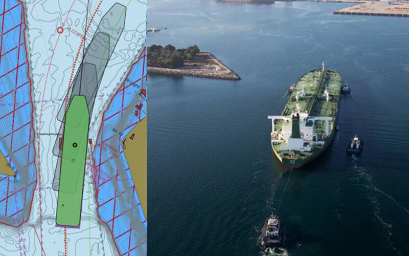
The new tool is called S-102, a set of data files developed under NOAA’s Precision Marine Navigation Program. S-102 files provide high-resolution depth data that can be added to NOAA’s standard electronic navigational chart (ENC). While the standard charts show the shoreline, breakwater, buoys and land area, S-102 files allow users to create detailed custom depth contours in their navigation systems and depict the seafloor in greater detail. Having worked closely with NOAA on numerous initiatives for more than 30 years, Jacobsen was the obvious choice to collaborate with the federal agency to demonstrate the new tool.
Jacobsen was also the top choice because it routinely upgrades its technology, which includes software that analyzes water levels, tides, currents, waves and weather. This information can be integrated with the digital charts, arming port pilots – already so experienced they can draw the contours of the San Pedro Bay from memory – with greater situational awareness of dynamic conditions in real time.
“There is no room for error,” said Thomas Jacobsen, president of Jacobsen Pilot Service. “We’re moving the largest ships in the world, and we need all the precision we can get. We’re talking about fully loaded supertankers that are 1,100 feet long, 200 feet wide and comparable in depth to a seven-story building.”
Under such conditions, the task is like threading a needle. “These ships have a draft of 69 feet in a channel that is 76 feet deep,” Jacobsen said. “We’re already close to the bottom and 1 degree of pitch can increase the ship’s draft by 10 feet. We have to use positive tides, the highly accurate S-102 charts, along with sophisticated ship dynamic modeling programs that predict the ship’s motion in the given sea state, so we can safely navigate these ships into port.”
The S-102 files are the product of nearly a decade of collaboration. The port’s Survey Division was integral to the evolution of the digital resource, said Jacobsen. “They understand the language of bathymetry and hydrography and quickly deliver the most current data to NOAA,” he said.
The Port of Long Beach survey team
Unlike most ports, the Port of Long Beach has an in-house Survey Division with the know-how and technology to study the port’s bathymetry – the science of measuring the depth of water and any changes in the submerged landscape over time. The group’s responsibilities also include topographic surveys of the port’s more than 3,500 acres of land, hydrology studies to ensure proper drainage at construction sites, and emergency response, whether something unusual appears to be on the seafloor or the U.S. Coast Guard needs backup in a storm. The team’s surveyors work with divers from the port’s Maintenance Division, and their high-tech tools include drones, a hydrographic vessel and fathometer. The latter measures water depth using sonar.
Most ports rely on NOAA, the Army Corps of Engineers or third-party contractors to survey their waterways, which typically happens every seven to 10 years, said Director of Survey Kimberley Holtz. “We survey half the port every year and we give NOAA the data it needs in the same format the agency uses. This allows NOAA to update its charts within 30 days,” she said.
The bathymetry team can measure the depth of the seafloor within 2 to 4 centimeters and its data is so accurate that Long Beach has NOAA’s top category zone of confidence (CATZOC) rating of A1, Holtz said. “This means the Port of Long Beach has the highest quality data for large vessels transiting its waterways,” she said.
Long Beach an ideal testing area
The Port of Long Beach was also an ideal testing area because its underwater landscape is less prone to change than the seafloor of other U.S. ports, said Jeffrey Ferguson, California navigation manager of NOAA’s Office of Coast Survey. “Absent a huge storm, we don’t see major changes,” he said. By comparison, the Mississippi River is among the nation’s most rapidly changing waterways because the mud flats along the heavily traveled commercial route shift daily.
After nearly a decade of testing and improving the S-102 data, which covers the entire San Pedro Bay harbor, Jacobsen fully transitioned to using the files in July. As a result of successful demonstration in Long Beach, NOAA has introduced the tool at the ports of New York/New Jersey and Boston. “Technically we are still using the beta version, which we continue to tweak to meet international standards,” Ferguson said. “We continue to add more ports and our goal is to provide the data to all major U.S. ports within the next several years.”
As the federal agency responsible for understanding and predicting changes in climate, weather, ocean and coasts, NOAA services and products – including the S-102 data – are free. “We make the barriers as low as possible for people to use our data for the greater good,” Ferguson said.
Ferguson is also eager to see how the data can be used more widely in the future. “Port pilots are the primary users because they need all that detail to guide ships,” he said. “However, fishermen searching for better fishing grounds, tugboat captains, scuba divers and marine geologists are also likely to benefit from this level of detail about what’s happening on the seafloor.”
The S-102 data is the next big step in the future of navigation, Ferguson added. “We’re looking forward to seeing more people use this product. I’m hoping someone I haven’t even thought of will see how amazing this data is and come up with a new application for it.”
– Port of Long Beach