The following is text of a news release from the U.S. Coast Guard:
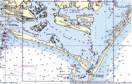
(WILMINGTON, N.C.) — The Coast Guard is seeking input from commercial and recreational mariners for an assessment of navigation requirements in the vicinity of Shackleford Banks and Harkers Island, North Carolina.
This Coast Guard Waterways Analysis and Management System (WAMS) study focuses on multiple waterways in the area between Beaufort Inlet and Core Sound, depicted on NOAA Chart 11545 and listed below:
Marshallberg
Westmouth Bay
Brooks Bay
Harkers Island West
North River
Ward Creek
Harkers Island East
Back Sound
Barden Inlet
Lookout Bight
Lenoxville Point
Shackleford Slough
Middle Marshes
Individual mariners and interested maritime industry representatives can provide input until Jan. 10, 2020. The stakeholder survey is available in both PDF and Word versions and can be found in the "attachments" box located on our Homeport page by clicking here.
In addition to stakeholder input, the study will also consider environmental concerns, user capabilities, technology, and available resources. The Coast Guard has no control over dredging in these waterways, however any information gathered concerning dredging will be provided to the appropriate agencies.
The WAMS study seeks to improve service delivery for marine safety information, modernize Coast Guard physical aids to navigation (ATON) systems and improve communications with marine transportation system stakeholders.
For further questions and to submit the stakeholder survey, email the Sector North Carolina Waterways Management Division at ncmarineevents@uscg.mil.

