The U.S. is gradually incorporating renewable energy sources for its future energy needs. We all have seen more and more solar panels on rooftops and wind turbines in fields as the availability and cost of these energy alternatives have become more and more economically viable. One of these renewable energy sources that has received a lot of attention in the past few years has been commercial development of wind energy using large wind turbines placed offshore along the East Coast. There has been successful development of wind energy turbines in some remote land areas and off the coast of Europe, which has proven to be an excellent alternative to conventional fossil fuel electrical generation.
Various coastal areas along the East Coast are in the process of becoming locations for several large-scale commercial wind turbine projects. It is an area with a lot of wind, it doesn’t use large land areas — which are becoming less and less available — and it is close to very large population areas. Just how this development will affect navigation is of great concern to the professional mariner.
For commercial wind energy to be a viable alternative, it must be on a large scale. Small projects with only a few turbines are very expensive to build due to the cost of cable runs, manufacturing and use of specialized construction vessels. Wind energy developers want to develop large areas with many turbines to cut down on the per-unit cost. The problem is that many of the areas that are suitable for this development are also areas that the professional mariner needs for access to and from our principal ports. This is complicated by the fact that building wind turbines in deeper water (over 100 feet in depth) is much more expensive than placing them in shallower waters.
The wind energy proponents make a strong case with many facts and figures as to how much energy is available and how many thousands of jobs will be created if they develop their goal of 53 gigawatts of power along the East Coast. Meanwhile, the tug/barge and ship operators make another strong case that they need complete and free access to all the coastwise areas, since diverting vessels to accommodate large-scale wind turbine projects will increase cost with added fuel and time. In between these conflicts is the U.S. Coast Guard, who is faced with the daunting task of developing a plan that everyone can work with and, most importantly, is safe. This project is part of an ongoing process called ACPARS (Atlantic Coast Port Access Route Study).
One of the most contentious areas is off the Maryland coast. As originally proposed, the location was right in the way of the approach to the Delaware Sea Lane. This is the main approach to the Delaware Bay and River, one of the major ports in the country, and the home of several major large oil refineries that supply petroleum products for the entire Northeast area. This WEA (Wind Energy Area) is relatively small as compared with other proposed areas with only 79,706 acres, but still capable of producing 875 megawatts or 2,943 GWh (gigawatt hours) annually. This area is significant, as it is among the first to be leased and many of the principles that will be used here will be used in other WEAs. The developer of this area will present a definite proposal as to the number and position of turbines in the near future. This proposal will be published in the Federal Register with a time available for written comments.
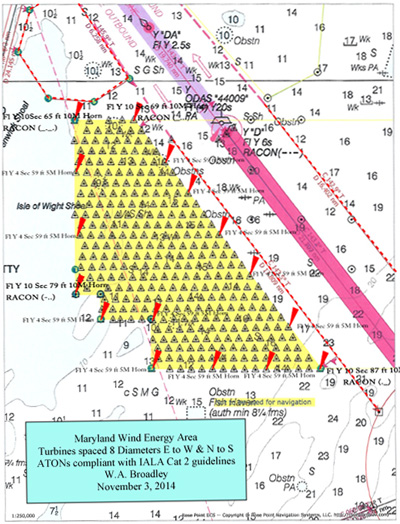
The proposal may look similar to what is described in the attached chartlet. You will note that 175 turbines are spaced at slightly over a half-nautical-mile separation — which is eight times the turbine’s diameter — along east/ west and north/south lines. This is to take the best advantage of the prevailing northwesterly and southwesterly winds, minimizing the wake effect caused by each turbine diminishing the output of the next downwind turbine. This is as presented by NREL (National Renewable Energy Laboratory) in its assessment published in a June 2013 technical report.
Many questions remain that must be addressed, especially as to how this proposal will affect professional mariners. How will our radars be affected by many turbines close to a major sea lane? Will we be able to see traffic on the other side of this WEA, both visually and by radar? Will our ARPAs (Automatic Radar Plotting Aids) be able to distinguish and plot moving targets within this WEA area? Is a routing measure, such as a TSS (Traffic Separation Scheme) extension, which was proposed and is depicted on the attached chartlet, necessary? How much separation is necessary from this routing measure to the WEA?
 |
|
The placement of wind turbines along the commercial shipping approach to Delaware Bay could have an impact on radar, lighting, aids to navigation and traffic separation. |
|
Courtesy Capt. William Broadley |
Another matter that will need to be decided is how this area should be lighted with ATONs (Aids to Navigation). The enclosed chartlet shows a lighting arrangement that is an interpretation of IALA (International Association of Marine Aids to Navigation and Lighthouse Authorities) guidelines. This will be decided by the U.S. Coast Guard ATONs personnel. This is also contentious as the bird conservation organizations and people who live along the shoreline will want the least number and visibility of navigational lights as possible, whereas the mariners will want as many and as bright as possible.
The area within this WEA will most likely be restricted in some form as yet to be determined. There are many reasons for this; one of interest is that, in certain freezing conditions, if any of these over 400-foot-diameter turbines picks up ice that drops off after a turbine is reenergized, it would be catastrophic for any vessel that happens to be too close.
Fortunately, we have some modern technology to help us out with some of these challenges. RACONS (Radar Beacons) may be used to help mark this area. Note that this chartlet depicts this WEA with RACONS on the four corners; however, this will have to be discussed and evaluated. AIS (Automatic Identification System) has been used to a great extent for years for vessel identification, but a new system is available where AIS can be used to describe a WEA and it will plot on an ECDIS (Electronic Chart Display and Information System).
In the BOEM (Bureau of Ocean Energy Management) leasing process of WEAs, the Maryland WEA involves an area close to a main ship fairway. Many of the problems that will have to be addressed here will apply to other areas that have similar problems. One of these areas is off the New Jersey coast, where a proposed large WEA is close to the existing Barnegat Sea Lane, which is the main Southern approach to New York Harbor. This area is also very close to several commonly used coastwise routes.
One of the professional tools that has not been discussed in terms of helping with spatial planning for WEAs and how it will affect the professional mariner is simulation. There are many marine simulators with various types of capabilities that have been used for training purposes, but none have been used for planning purposes. Appropriate routing measures, ATONs, AIS, RACONs and buffer areas could be analyzed and evaluated so logical comparisons can be made to help make these important decisions. It can be determined if special navigational procedures or VTISs (Vessel Traffic Informational Service) are necessary for vessels as they navigate close to these WEAs.
The addition of offshore wind farms along the Atlantic Coast will certainly make navigation more challenging. Instead of taking the most direct routes, vessels will have to take routes that will go around WEAs and follow published routing measures. Mariners will have to navigate relatively close to large tower structures, making what used to be an easy, laid-back type of watch, into one where mates and captains will have to be on their toes. This will especially be true with reduced visibility and/or heavy traffic situations.
The areas along the Atlantic Coast are very busy with a great deal of marine traffic including both large ships and tug/barge units. This traffic will increase with the new larger locks in the Panama Canal, which will mean that vessels engaged in the Pacific trade may be calling at various East Coast ports. There will be an increase with the number of coastwise vessels, as this trade will augment our overloaded rail and road infrastructure. The mariners of the future will have many new challenges, especially dealing with large-scale wind turbine projects located off the coast. These challenges can be met, however, if we all work together — including professional mariners — in the shared interests of safe navigation, clean domestic energy and economic growth.
Capt. William Broadley, a retired federal pilot and tanker master, is a marine consultant and expert witness. He is a participant in the Atlantic Coast Port Access Route Study and is a member of the Mariners’ Advisory Committee for the Bay and River Delaware.

