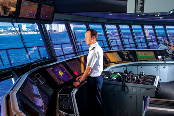
On a morning voyage out of Bainbridge Island, loaded with Seattle-bound commuters, the Washington State Ferries boat Tacoma inches out of its Eagle Harbor berth. While the ferry travels eastward toward the busy Puget Sound commercial shipping lane, Capt. Bob Merideth cannot see the southbound vessels because a land mass — Wing Point — blocks his port-side view.
Still, the captain knows that the icebreaker Polar Star is in the sound. So is the 98-foot workboat Motega. At a glance, the two display screens in Tacoma’s integrated bridge system (IBS) offer Merideth a combined view of the electronic chart, radar and automatic identification system (AIS). He knows the vessels’ positions and track lines, and the IBS helps Tacoma avoid them and Tyee Shoal.
“This has improved so much over the years — the quality of the displays, the way the data are displayed, how you pull it up, how the AIS is interfaced with the radar, the ability to tailor the display, the brightness, the color of the track line,” Merideth said. “I want to turn it on, and I want to plot what’s relevant. This is the shipping lane — the chart — right on the radar here.”
The customized IBS in 460-foot Tacoma’s pilothouse is equipped with Furuno components including a FAR-2127 radar, MU201CE remote display, FA150 AIS and redundant SC-110 satellite compasses. Inside the SC-110 are the global positioning system (GPS) models GP150D and GP90D. The compact distributor, course repeaters and gyrocompasses are Anschütz products. Weir-Jones Engineering provided the draft indication system.
 |
Merideth uses two display screens. He sets one radar for a three-quarter-mile close-up view. The other is a six- to eight-mile view. The captain uses different colors to denote the channel contours and other vessels’ track lines. On split screens alongside, he calls up various data including AIS descriptions of other vessels.
“We cross the shipping lanes. It gives me the whole range, so I can see what the other people are doing,” Merideth said. “I can track all the (commercial) traffic and the small boats. Everything up close to me is magnified. I keep our own track line yellow, so it stands out from all the others.”
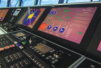
Marine electronics makers and system integrators — whether it’s ComNav, Kongsberg, Raymarine, Transas, Furuno or others — have contributed to IBS improvements in recent years, making it easier for ship officers to operate safely. Recent trends include larger and clearer display screens, split-screen capabilities, multi-functionality, remote monitoring and the inclusion of more vessel systems in the integrated bridge.
“Today’s modern multi-functional displays allow the user to select numerous systems on their individual displays, such as specific machinery being repaired as well as security cameras on the vessel, the ship’s ECDIS display showing its current position and radar targets, to name a few,” said Dave Darr, president of Marine IT Solutions Inc., a New Orleans-based system integrator.
An additional key development has been common hardware/software networks that have improved data integration and consistency, resulting in “the greatest scalability and flexibility ever,” said Darr, who serves the commercial offshore and new-construction markets.
“Modern IBS systems offer common hardware-software solutions instead of each system or station needing their own specially designed processor and system-specific software,” he said. “From a maintenance point of view, the more modern IBS systems provide a major reduction in the need for different processors, parts and the need for individual diagnostics. There also has been a major reduction in cabling as well as weight due to the new system designs and interfacing.”
The maritime sector has taken advantage of technology developed for the television and computer industries. Whereas 21-inch screens in the old TV shape were the standard for marine displays, now there are 26-inch screens with higher picture definition. Captains can call up information on smaller split screens on the right-hand side of the radar/chart view.
“For sure there is a demand for bigger displays and a wide-screen display,” said Doug Anderson, sales director with Simrad Navico. “When you have a multi-functional display, you can bring more data into the display. … It meets the requirements for a radar display, and on the side you have conning-based data, or we can incorporate our broadband radar on the same display.”
Aside from the standard combinations of radar, chart, AIS, GPS and autopilot, additional functions have been built into IBS data streams to help monitor various ship operations, tides, currents and other environmental inputs.
“The evolution of all this seems to be you start with the chart and the next things are the radar overlay and then the 3-D satellite overlay and now there’s the weather overlay … with Doppler radar and wind speed,” said Tom Isaacson, co-founder of Big Bay Technologies Inc., a Seattle-area provider of marine displays for workboats. Available, too, are engine management statistics, navigation guidebooks, Google Earth, and the interactive guidebook Active Captain.
Shipowners are finding it useful to add monitors throughout the vessel, sometimes for other bridge officers or at secondary pilot or conning locations, or even in the engine room.
Recently built offshore supply vessels have had as many as 12 monitors installed — five of them in the bridge’s forward operating area, said Paal Liset, IBS product manager for Marine Technologies LLC, a navigation electronics provider and system integrator in Mandeville, La. Aside from convenience, the additional monitors are useful in case something goes wrong with some of the bridge electronics.
“By having everything available at other work stations, you increase redundancy,” Liset said. “If one station fails, you still have everything available at the other stations.”
To handle the proliferation of data, more robust onboard networks have been developed, said Scott McCrory, business director for Sperry Marine. The newest cruise ships have even more displays throughout the navigation and machinery spaces — and even in passenger areas.
“We’ve had as many as 15 on a Royal Caribbean vessel. Thirty or 40 percent of these are multi-functional displays, so there is a lot of data moving around the network,” said McCrory. “We are allowing that data to be updated in real time and move quickly over the network … and react more quickly to the commands.”
Darr said the newest IBSs help operators to customize voyage monitoring, display more conning information and eliminate blind spots by combining three or more radar pictures into a 360-degree view. Anderson said the 360-degree radar view is useful as an anti-piracy tool.
“Optimal fuel consumption is another display that the captain is calling up, so he can see how his operation is having an effect on fuel consumption,” said Kjeld Ditman of L-3 Lyngsø Marine, a unit of New York-based L-3’s Marine & Power Systems division.
IBS data is moving off the vessel, too. More and more, port captains can monitor the operations of the vessel.
“Nowadays people are doing wireless to the main saloon, and the owner on shore can get it on his laptop and he can see the route for the day and save it on his thumb drive,” Isaacson said.
IBS providers realize that vessel operators shop for TVs and computers for their homes and notice that electronics prices are getting cheaper for those items. They are demanding the same pricing trends for their marine components.
“Processing is getting faster, the screens are getting bigger and the cost of the LCDs is coming down,” Anderson said. “So we’re able to bring more functions at a better price.”
A mariner can’t put a price on human life. Even as they are becoming less expensive, the latest IBS packages have become more valuable during potential life-threatening crises. Aboard Tacoma, Merideth points to his screen and cites how the system remembers the track line that the ferry just took.
“If I have a man-overboard situation and we have to go back and find somebody in the water, I have the ability to go back on my line,” said Merideth, who has 25 years’ experience.
All the additional information on the screen is not meant to replace traditional navigation skills. Rather, it’s to aid captains by enhancing their understanding of what’s going on around them. Ultimately, IBSs are designed to make navigation safer — and can save money too.
“You may be able to operate the vessel more efficiently than you can with your seaman’s eye … and reduce damage if you are operating in heavy weather,” McCrory said. “We’re working on building intelligence into the system to help you do that.”
L-3 is notable in that the company not only integrates IBS but also develops and owns each major component. L-3 supplied the navigation electronics for the new cruise ship Norwegian Getaway, which was due to enter service in January 2014 from Miami. Getaway’s IBS has a world-record 50,000 data points coming into the system, said Brian Pope, senior vice president of business development at L-3 Marine & Power Systems.
“So we are becoming more like an airplane in terms of operating a ship, if they want that,” Pope said.