The following is the text of a news release from the University of Connecticut:
(STORRS, Conn.) — Major research discoveries generate news headlines. But a research undertaking by one University of Connecticut engineering lab seeks to forestall some headlines of a different kind.
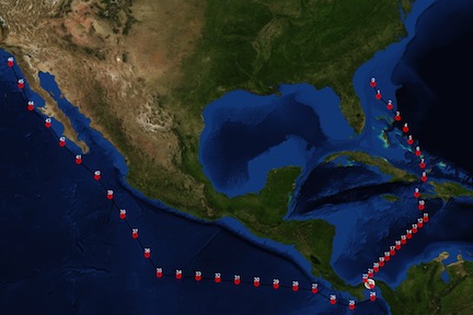
The loss of life because of weather events, as happened on Oct. 1, 2015 when cargo ship El Faro sank with its 33-member crew in Hurricane Joaquin, is one example. Transcripts released by the National Transportation Safety Board showed an increasingly anxious and panicked crew as the 790-foot vessel sailed into the raging storm two years ago.
Software developed by Krishna Pattipati, UTC professor in systems engineering at UConn and his research team, in collaboration with the U.S. Naval Research Laboratory-Monterey, may go a long way toward avoiding such tragedies.
The prototype, named TMPLAR (Tool for Multi-objective Planning and Asset Routing), is now being used by the Navy to vastly improve the ability of ships to reroute through unpredictable weather. It is the type of technology transition that the new National Institute for Undersea Vehicle Technology based at UConn Avery Point, is now able to foster.
Created by Pattipati and electrical and computer engineering graduate students David Sidoti, Vinod Avvari, Adam Bienkowski and Lingyi Zhang, and undergraduate students Matthew Macesker and Michelle Voong, TMPLAR is still in development, but it has already been fully integrated with the Navy’s meteorology and oceanographic weather forecasts.
Members of the UConn team meet weekly with Navy officials, via teleconference, to discuss project updates and receive feedback.
“Their progress is fast,” said Sidoti. “Frankly, it’s kept us on our toes as we try to manage both our academic responsibilities here at UConn while enhancing and updating the software.”
TMPLAR is like a much more complex version of Google Maps, because it will be applied to ships and submarines, where there is no underlying network of roadways to navigate.
In Google Maps, a user typically seeks to maximize the average speed of travel between start and end locations to get to a destination in the shortest amount of time, hence the route may favor highways instead of back roads.
Pattipati’s team is now approaching problems with upwards of 17 or more objectives, which may change depending on the vehicle and the conditions.
The algorithms take into account obstacles such as ocean depth, undersea pipelines, cables, oil rigs, for example. And they factor in multiple user objectives, whether to traverse to an area to minimize travel time, maximize fuel efficiency given the predicted weather, accomplish training objectives, or maximize operational endurance.
“The tool guarantees safe travel from any point in the ocean, above, on, or below its surface, while making choices en route that optimize fuel consumption and cater to any set of objectives of the operator,” said Sidoti. “Using special clustering techniques, the tool’s algorithms have even been applied to finding low-risk routes that avoid storms or hurricanes.”
The next step for TMPLAR is programming the tool for use by aircraft, such as drones.
Last month, Pattipati and Sidoti traveled to San Diego to demonstrate the capabilities of the software to the Space and Naval Warfare Systems Center Pacific. Their algorithm is now going to be integrated with a tool for aircraft carrier strike group planning.
The lab first published details about the software last year in the journal IEEE, the world’s largest professional organization for the advancement of technology. Avvari, one of the graduate students, will detail some of the enhancements that have been made since then at an upcoming professional conference.
And, as the software transitions to operational settings, the team is looking to speed up the capabilities to output smart weather-informed route recommendations in less than a second. Adding neural network modules to TMPLAR is another new horizon; artificial intelligence would help condense solutions so it is less overwhelming to a user, said Sidoti.
When he reviewed the factors faced by the crew of El Faro using TMPLAR software, Sidoti was able to find safe routes for the ship that involved waiting at waypoints and varying the ship’s speed in order to avoid unsafe environmental conditions, while also reducing costs of the route.
The Coast Guard’s report on the tragedy – released just a month ago – said the captain misjudged the strength of Hurricane Joaquin and should have changed the El Faro’s course.
Sidoti found up to eight possible safe routes using TMPLAR. That’s the sort of information he hopes other captains will have.
Recently, the team received notification that the software was demonstrated to onboard ship navigators who were interested to the point that they requested the ability to use it in order to plan and test it on a real-world deployment.